 |
| ( Gardez patience, l'affichage des cartes prend un peu de temps ! ) |
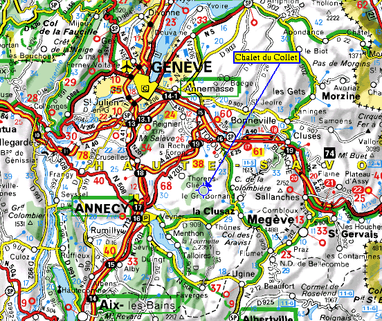
| Pour vous permettre de vous
situer voilà une carte qui vous
montre les 3 lacs de proximité: Léman, d'Annecy
et du
Bourget. Les villes de proximité sont Genève et Annecy. Vous pouvez voir aussi sur cette carte la proximité des frontières suisses et italiennes.
 Hier
eine Karte auf der Sie die 3 in der Nähe liegenden Seen
erkennen können - Genfer See, See von Annecy und Bourget See. Die
am nähesten liegenden, grösseren Städte sind Genf und Annecy. Hier sehen
Sie auch die naheliegenden Grenzen zur Schweiz und Italien. Hier
eine Karte auf der Sie die 3 in der Nähe liegenden Seen
erkennen können - Genfer See, See von Annecy und Bourget See. Die
am nähesten liegenden, grösseren Städte sind Genf und Annecy. Hier sehen
Sie auch die naheliegenden Grenzen zur Schweiz und Italien. |
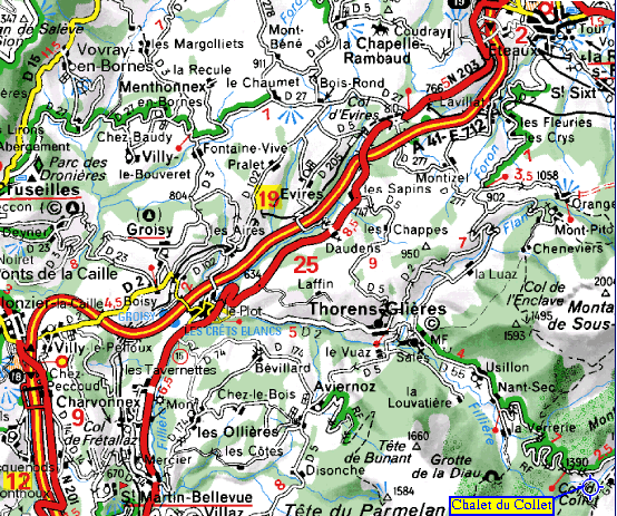
| Ce zoom sur la carte
vous permet de voir le village de
Thorens-Glières qui se trouve à environ 12 km du Plateau des Glières.  The zoom on the maps enables you to see the village of Thorens-Glières,
situated at about 12 km from the Plateau de Glières. The zoom on the maps enables you to see the village of Thorens-Glières,
situated at about 12 km from the Plateau de Glières. Diese Vergrösserung der Karte zeigt Ihnen den Ort Thorens-Glières, 12 km vom Chalet du Collet entfernt. Diese Vergrösserung der Karte zeigt Ihnen den Ort Thorens-Glières, 12 km vom Chalet du Collet entfernt. |
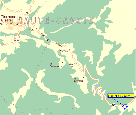
| Et ce zoom vous montre la route
depuis Thorens-Glières jusqu'au Chalet du Collet. Traverser Thorens-Glières. A la sortie, au niveau de la fruitière, prendre à gauche direction Usillon et Plateau des Glières. Traverser le hameau de Usillon et continuer jusqu'au bout de la vallée. Monter en direction du Plateau des Glières. Arrivé au Plateau (Panneau : "Ici commence le Plateau des Glières"), suivre la route qui descend. En bas, au croisement, prendre à droite, c'est le premier chalet à gauche (à 20m du croisement, panneau " Gîtes de France"). Ca y est, vous êtes arrivé !  This Map shows you the access road from
the village to the Chalet du Collet. This Map shows you the access road from
the village to the Chalet du Collet.Go through Thorens-Glières, and at the end of the village turn left in the direction of Usillon and the Plateau des Glières. Keep on this road and go through several little villages to reach the end of the valley. Keep to the left, up in the direction of the Plateau des Glières, and continue to the top of the mountain. When you reach the top and see the sign "Here begins the Plateau des Glières", follow the road down to a junction, where you turn right. The Chalet du Collet is 20m from the junction, the first house on the left. You can see the sign " Gîtes de France".  Diese Karte zeigt Ihnen die Strasse von Thorens-Glières bis zum Chalet du Collet. Diese Karte zeigt Ihnen die Strasse von Thorens-Glières bis zum Chalet du Collet.Fahren Sie durch Thorens-Glières. Am Ortsausgang, biegen Sie links ab in Richtung Usillon und Plateau des Glières. Fahren Sie durch Usillon und weiter bis fast zum Ende des Tals. An der Kreuzung, fahren Sie die Strasse links hoch Richtung Plateau des Glières. Oben angekommen ( Schild : "Hier beginnt das Plateau des Glières" ) fahren Sie die Strasse weiter, diesmal runter, bis zu einer Kreuzung. Hier fahren Sie rechts und das Chalet du Collet ist das erste Haus auf der linken Seite ( 20m von der Kreuzung entfernt, Schild "Gîtes de France"). |
